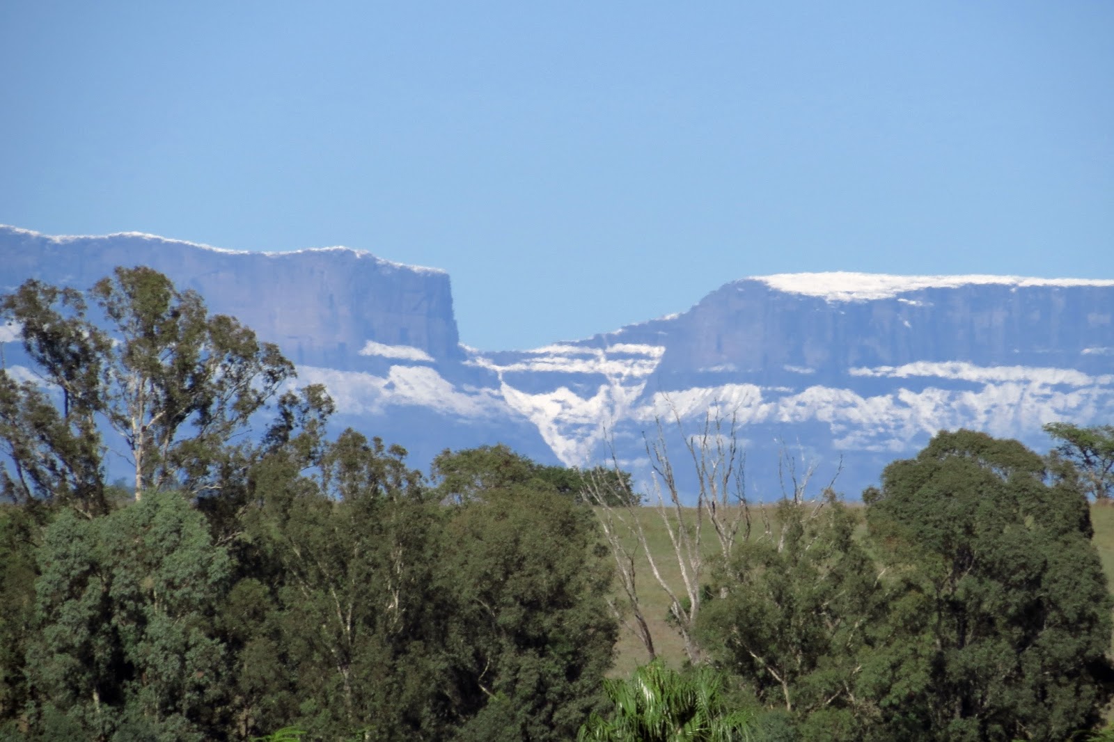
This is our third or fourth snow fall on the Berg this winter, and winter hasn't really started yet. Must be global warming, I mean climate change, to be PC.
On Friday on Saturday we had heavy, almost non-stop rain, for 24 hrs, rain at this time of the year means snow on the Berg.
Looking west, a photo of snow on part of the Berg. Looks as if there is enough snow up there, (10,000 feet +) to ski, just don't ski over the edge. The farm in the foreground is the neighbouring farm just to the east of where I live. As you can see I live very close to the Berg.
Same scene just zoomed in a bit.
I took about 30 photos and every where you look you see trees. South Africans are great tree planters, the Worlds largest man-made forest is in SA, and this forest is planted in our largest city, (strange as it may seem) Johannesburg and it's suburbs. Other cities in SA are not far behind, Pretoria,(the administrative capital)* is known for it's hundreds of thousands of Jacaranda trees, a sight to behold in October when the whole city turns purple.
*South Africa has three capitals, (not counting provincial capitals, 11 of them) Cape Town the parliamentary capital - parliament meets there-, Pretoria the administrative capital, and Bloemfontein the judicial capital, seat of the *Supreme court.
* Supreme court, not the same thing as the US supreme court, our equivalent the US Supreme court is our Constitutional court.
This mountain is about 60 km's away from where I was standing to take the photo.
Click to enlarge.
The peaks of Giants Castle at 3000 meters plus.
Took this photo one evening last week.
Click to enlarge.
Looking north, the Drakensberg of to the left.
We had rain again yesterday, lots of rain, (I'm thinking of moving somewhere drier, like British Columbia, or one of the NW Pacific coastal states of the US, like Washington state) with it came a sudden drop in temperature. Woke up this morning and it was freezing.
Went to school to do some work in the library, and we have a lovely view of parts of the Berg, (not called Drakensview school for nothing) and I snapped these photos.
Click to enlarge.
Snow in April, and it's still snowing in parts of the Northern hemisphere! Must be this global warming thing. View of Giants Castle with a light dusting of snow.
View of the Berg just a bit north of Giants Castle, slightly more snow. Our first snows usually only fall towards the end of May, so this is very early. Because of all the rain we've had people have been predicting a very cold winter this year. Who knows maybe they are right.
Rain storm over the Drakensberg.
Click to enlarge.
In the middle distance, on the right, the buttress of 'Nthabamhlope, (White Mountain). The rain can be seen just behind it.
Sunday evening I was able to take my dogs for a walk along one of the dryer tracks on the farm, only one or two small puddles so they could not get too dirty. Although rain was predicted it held off till much later when we had a very light shower. This afternoon it was a different matter and between 4pm and 4:30 the rain came bucketing down.
This is mainly a crop farm with only a few head of beef cattle.
Cosmos, the first sign of autumn.
The mountains on the horizon are 50 or 60 kilometres away, this part is known as the Northern Berg, (Drakensberg)
West, north-west.
Looking North, north-west. The centre-pivot irrigation that stretches across all three these photos, is more than 300 meters long. The whole system can be moved to a different pivot point so other fields can be irrigated. There are two other smaller centre-pivots on the farm. The maize in the foreground is intended for silage and will be sold to a neighbouring dairy farm.
Your intrepid African fly fisherman braved the dangers and hardships of Africa to bring you one photo of one 6 inch rainbow trout. Even if though I say so myself, a very beautiful little fish and worth all the effort to catch it.
Click to enlarge.
Wild rainbow, this stream was stocked once more than a hundred years ago and never again. Since then these fish have thrived and flourished here in the cool, pure, crystal clear waters.
The best part though is I caught it on a fly I tied myself, a Zack nymph, (a South African fly) and with a 2 weight fly rod I built. This little fish gave a very good account of itself in the fast water, putting a serious bend in the 2 weight.
The setting, Injasuthi Nature Reserve.
The flat rock and it's pool. (See dialog below).
While I was assembling my fly rod next to the road bridge crossing the stream, a car (huge 4 x 4 actually) stopped next to me and a young man stuck his head out, and said, "Walk down stream about 200 meters to a big flat rock and you'll find great fishing in the pool below it. Fish on the bottom with a weighted nymph and add some split shot to keep the fly down, the water is deep, and the fish are holding right on the bottom". Then he drove off with a wave and, "Good fishing".
I first tried my luck about 50 meters upstream, where I have often fished, missed several strikes, then decided to follow the young mans advice and head downstream. Just below the bridge was a nice looking bit of water so I decided to try there first. But I eventually gave up, not because I thought I would not catch anything but because I got tired of waving back and greeting everyone as they drove or walked over the bridge. South Africans are a friendly lot and will greet, and talk to, anyone and everyone. So I headed downstream to the fabled flat rock and it's pool full of fish.
Easier said than done, usually one could walk right next to the stream, but the water was up, bank to bank, so it meant walking through the bush and grass above the stream bank. Now in theory that doesn't sound too bad but the grass is a meter to a meter and a half tall, it's hard and tough, to add to the fun, there are hard tough shrubs, just as tall, (or taller) and thorn bushes. Furthermore you are walking on boulders from the size of your fist to the size of your head. The grass is so thick you can't see the ground so you put your feet down hoping to luck, and this is great snake country. As I pushed and struggled my way through this "jungle" I kept thumping my wading staff on the ground to scare of any snakes.
An open patch on my route downstream.
To cut a long story short it took me almost 40 minutes to cover the 200 meters, only when I got there did I see there was a much easier route directly from the road. Well you live and learn. (I hope).
The pool, there is an eddy just in front of the rock and a deep undercut under the rock and under the grassy bank. I got several takes by letting my fly drift right through to the tail of the pool and swing, but missed them. My problem was that although my nymph had a bead head and a few turns of lead wire it wasn't enough to get really deep enough, and my container of split-shot was lying at home.
A view upstream. Although the water was flowing very fast, there are plenty of nice holding spots. Against the far bank was a deep run with a nice undercut.
Cape Grass bird, (Sphenoeacus afer). I spotted this bird on my way out, habitat; rank grass-land. Well the grass here can be described as very rank.
Just another S#@t day in Africa.
Gorges of Gorges' grouse, groused yesterday that the area was too flat for his liking. Well I thought I'd show him how mountainous it really is. Photography can be very selective and does not always show reality, yesterdays photos left out the mountains. The farm actually lies just to the right of center, towards the back of my header photo.
The first birds I came across were these two spur wing geese. They are not the prettiest of birds but very imposing, standing about a meter tall. In the middle distance a Swainson's spurfowl is scurrying away.
A cropped picture zooming in on the Drakensberg, Champagne Castle area, about 60 km away.
Sunset over the mountains looking west, north-west. The hill in the foreground is about 3 km away. I think I'm going to get some stunning sunset photos from this point, couldn't hang around today as I was 3 km from home with a rain storm approaching. Just made it home, and it's still raining now at 8 pm.
The northern end of the farm with the Little Bushman's river running through the valley. I mentioned this stream in yesterdays post. This is a big farm and by the time we got home my dogs were exhausted and we only covered a small part of it.
"A fisherman is always hopeful - nearly always more hopeful than he has any good cause to be." Dark on the water. by Roderick L. Haig
-Brown.
This was the case with me when I left yesterday morning to go fishing at my favourite still-water fishing spot, Grantchester dam on Defence farm in the Kamberg valley. How come I was fishing on a Monday morning? Well it was a public holiday, Heritage day, here in sunny SA.
Click to enlarge photos.
Stopped along the way to take a photo of this waterfall.
This waterfall on the Mooi River, (Afrikaans for "Pretty River") will be no more in a year or two's time. The Department of Water Affairs, is busy building a huge dam more than 10km downstream. Above these falls the Mooi River only has Brown trout, after the dam has been built, bass, yellow fish and carp will invade the upstream waters. Wild Brown trout have been in these waters for more than 120 years, who knows for how much longer. Nothing kills a river quicker than a dam.
A little further I took several photos (about six) to make this panorama of the Drakensberg. On the far left you have Giants Castle, where the Berg turns west, south west. On the far right the Berg turns in a long curve west north west and then north, forming the famous Amphitheatre of the Berg. The part of the Berg seen in the panorama is known as the central Berg. From Giants Castle on the left (south) is known as the southern Berg. From the Amphitheatre it's known as the northern Berg.
This is almost the same panorama as my header photo, from more to the south and not quite as zoomed in and includes more towards the north.
A panorama of Grantchester dam on Defence farm. As I have pointed out in a previous post here in the good old R of S. A, (Republic of South Africa) we also call the piece of water behind the dam wall, "the dam". All impoundments in SA are called dams, as some one has said it's one of those South African things. At this point the dam is more than a hundred meters wide. The dam extends way off to the left, (east) but to include it all would take too much space. My fly line can be seen lying on the water, where the fly line ends there is a steep drop-off into deep water.
Since I've started Blogging, (18 months ago) I have caught no trout in this still-water, yet my biggest trout, a hen of almost 24 inches, was caught here, (about 7lbs). Trout grow very fast in these waters as they are very fertile.
I think I've read too many fancy writing about trout fishing in still-water. Back then as a novice, it was cast and strip back as fast as I could, the startled trout would grab the strange, fast moving insect before they realised it was a fake, now I use all sort's of fancy retrieves, all of which the trout have seen before. (Well I need some excuse).
The fish in this piece of water are basically wild, put in as fingerling's, (3 inches) they grow large by surviving the natural dangers a wild trout would survive. It's definitely not a "put and take", water.
Looking across the water to the Berg in the background. Still some snow to be seen on the Berg.
The buildings are the milking parlour and some sheds. The parlour doesn't look like much on the outside, but is state of the art inside and milks several hundred dairy cows twice a day. South Africa has extremely strict laws concerning milking parlour hygiene and interior construction, (overkill in my opinion), and it has put many smaller dairy farmers out of business.
Another view of the Berg across the water, more to the south.
The water was actually quite murky and not quite as blue as the photo suggests, (though it usually is).
On my way to work this morning I took a little detour to see if I could get an early morning photo of the sun shining on the Drakensberg. I took several photos then "stitched" them together to form panoramas. I didn't get the "stitching" absolutely right, but with practise I might just. After stitching them I manipulated them further.
Click to enlarge.
Looking westward, with the sun rising behind me.The two halves don't have exactly the same exposure, the photo on the left is lighter and one can see where they join in the middle.
The same photo , now a water colour painting.
In this panorama I zoomed in to show more of the Drakensberg, about 35km from where I was standing. The N3 highway can be see running north/south in the middle.
Here the photo has become an oil painting.
Yesterday was the last day of our two week autumn school holidays and I decided I would make the holidays end with a bang with a nice long hike at uMkhomasi Wetlands Nature reserve. Well the holidays almost ended in a whimper for me. But more about that a bit later.
Click on pictures to enlarge.
A long and winding road. This is the same road to Loteni, down the mountain and up the other side. Loteni lies on the other side of the mountain. My destination way down in the valley below.
Entrance to uMkhomasi Wetlands Reserve, proclaimed a reserve in 1973, previously it had been a privately owned farm. uMkhomasi is part of the uKhahlamba Drakensberg World Heritage Site, of 2,428 square kilometres in size. The park stretches from north to south along KwaZuluNatal's border with Lesotho.
There are no roads in the park, except those leading east to west to particular camp sites. If you want to travel from north to south in the park you have to walk.
After paying my entrance fee and signing the Mountain Rescue Register, I started my hike. The point I wanted to reach was one of the caves which can be used by hikers as shelters, the Cypress cave, about 2 hours easy hike.
The hiking trail starts just outside the resident rangers house and leads down to a small stream at the bottom of the valley, across the stream and up the mountain on the other side. All the hiking trail have these creosote treated gum tree poles across the every couple of metres. This is to prevent water run off from turning the trail into an erosion gulley. The poles are held in place with steel staples that are driven into the ground, as can be seen on the left hand end of this pole.
The first part of the climb started easily enough but got steeper and steeper with the trail climbing up the mountain in short zig zags. After about 30 minutes the inclince became easier and the trail rather like an easy meander up the mountain.
I was ambling along all alone in this huge empty space, with just the mountains the blue sky and a cool breeze blowing on my face. I thought to myself this is pretty much what the first man Adam must have felt like, not another human on the planet just me, caught up in all this beauty.
Suddenly a half choked scream rent the silence, in a language before language, and in my brain the warning lights flashed a word, also in a language that existed before language, snake! snake! snake!.
Inches from my left leg a spitting cobra was poised to strike, hood spread, and tongue flicking. Well I won't be lying much if I said I did three back-flips, and four cartwheels from a standing position and ended up pretty much in the same place, just a few inches further. All the time going through my mind was, "take a photo, take a photo!" And I did, I thought I had got several photos of the snake but I only got three, the rest just showed grass and bare ground.
The snake took fright at my gymnastics and decided to make an escape.
Photo of the snake above, heading for cover. You can see the hood, still slightly spread with the darker head on the left. This snake was about a metre long, +- 3 feet. Here KwaZuluNatal the snake is known by it's Zulu name, "mfesi". Say the word mfesi and most people here know what you are talking about.
Photo Internet.
This is the sight I saw, spitting cobra, Hemachatus, heamachtus. No wonder I was capable of such amazing gymnastic, or at least some very fancy foot work.
The venom of the spitting cobra is neurotoxic. A spitting cobra's main defence though is to spit venom, up to 2.5 meters, into it's attackers eyes, this is extremely painful and can cause blindness. If I had been bitten there's not much chance I would have made down the mountain on my own. Fortunately for me this is not an aggressive species of snake, most of the time the only thought going through their small brains at a time such as this, is escape.
After my heartbeat came down from what felt like 500 beats a minute to something more normal, I continued on my hike.
More about this in my next post.
Land of mountains, rocks, antelope and more water.
A little way further down the road we came upon a road repair crew grading the gravel road. They were doing more than just grading away the corrugations on the road surface, but were busy with a major rebuilding of the road top. With the Caterpillar grader there was a Huge Bell tractor towing an even bigger road roller compactor.
Freshly graded road. On our return late that afternoon the crew were still at work. Further on we saw how well they had rebuilt the surface, it was almost like travelling on a tarred road.
Another farm sign. The name "Snow Top", shows how high the road is here. From here you can see a huge piece of southern KwaZuluNatal,(I'd hate to guess the size one can see, but it was several hundred square kilometres), with the Drakensberg stretching way to the south along the western edge.
The crest of the pass, from here it was down hill and hairpin bends into the Loteni valley. We had breakfast here, fresh buttered bread, boiled eggs, and hot strong coffee.
The first hairpin bend. Note the right hand top point of the mountain in the background, a close up of this point in the second photo after this.
This photo shows the steepness and winding nature of the road. This stretch of road has already been repaired and if you enlarge the photo you will see the surface is quite good.
Close up of the point referred to before, I call this the Loteni Sphinx, weather it actually has a name I don't know. You can see how huge pieces have broken away from the sandstone cliffs and fallen down the mountain.
Some of the huge blocks of rock that have broken off and rolled down the mountain. These boulders are very big.
This boulder was right next to the road, about three stories high. It looks a bit like the stern of a sinking ship, even has a rudder sticking out the back.
While I was photographing these boulders, the Italian leprechaun started shouting excitedly that I must look,"there goes an antelope". Sure enough there a Mountain reedbuck was racing up the side of the mountain. Taking photos almost by reflex I manage to get the following two photos.
Mountain Reedbuck, (Redunca fulvorufula).
Second photo. To appreciate it properly it needs to be enlarged by clicking on it. In the top right hand corner you can see the neck and head of another reedbuck peering over a small ridge.
Our first glimpse of the Loteni river, we still had about 5km to go before we got to the Nature Reserve.
More in the next post.
Spent Saturday evening making sure that my fly fishing tackle was in order for a trip to the Injasuthi river. Took out my two weight rod and reel, cleaned the reel and lubricated it, cleaned the fly line and checked the leader and tippet, replaced tippet. Emptied all the pockets on my fly fishing vest and made sure that only the necessary items were replaced, including the two fly boxes of flies that I have been tying these past few weeks. Spare reels of 4, 5 & 6X tipped material checked.
Everything laid out neatly for an early start, rod, reel, fly vest, wading boots, net, etc. Spent the rest of the evening tying some more soft hackle flies to add to my fly boxes.
Click on photos to enlarge.
Got up at 5 this morning, had a cup of coffee and packed everything in the car. Fed the dogs, the cat and the birds. Had some muesli and just after 6 I was on the road heading west. Theoretically the trip should not take more than a hour, most of the road is a lovely tarred road, but for more than 30km it goes through Zulu tribal area, so you slow down to avoid cattle, goats, sheep, chickens, people and the stray pig. Not to mention that I stopped every couple of minutes to take photos. Above is my first clear view of the Drakensberg just catching the early morning sun. Still about 30km to go.

Just 13km from where I took this photo to the Injasuthi camp grounds, but the road from here is just a pot holed track. I think that it's a policy of the conservation authorities to keep this piece of road as bad as possible, so that only those dedicated wilderness enthusiasts bother to make the trip. This bit of road takes almost 30 minutes as you are reduced to driving at a snails pace, you could almost walk faster. Then suddenly about 3km from the camp you have a perfect tarred road to complete the journey.
Starting to get real close now and I can almost taste the fishing. Note the waterfall, just off centre to the left, plunging down several hundred metres of vertical mountain face.
The zoom lens makes these peaks look close, but from the camp they are several hours of hard hiking away, just to get to the bottom. For the climbing enthusiast there are more than enough challenges, for the hiker and camper, contour paths go all the way to the top. Just make sure you are fit and well equipped before you start.
Injasuthi peaks.
Got to the office at about 07:45 to pay my entry fee and buy an angling permit for the day. While waiting for the office to open at 8 I spotted this baboon sitting casually on the lawn. What it was actually doing, was watching people who were having breakfast on the veranda of their chalet, just waiting for the moment they might leave it unattended.
After paying I drove down to the river and parked the car, put on my wading boots, fishing vest, cap and hung my camera around my neck. Grabbed my day pack and reached for the rod tube, .... not on the back seat, scratched around behind the front seats, not there, even felt under the seats, (as small as it is it wouldn't fit there). Then the reality dawned on me, I've forgotten my fly rod at home!
What to do now? No way I can go back totally defeated by my own forget fullness!
So I decided to do some exploring of the river. I tend to fall into a rut, find a good place to fish and keep going there, trip, after trip. Got back in my car and drove a kilometre or two back the way I came, following the river down stream. Found a parking spot next to the road and headed for the river, down a faint track, through dense scrub and long grass. As we say here in South Africa, "I had good luck with the bad luck". I found two stretches of beautiful trout water after about 3 hours of exploring. Next week end I'll be back, I might just camp there from Friday afternoon after school.
As I drove out of the reserve I saw this stream tumbling down the mountain. I was far away so I only zoomed in on the top half of it.
Next two post will be about my exploration and the fishing spots I found.